
- Android
- Offline maps
- CoT format
- Civilian and military pilot editions
Honey Badger App
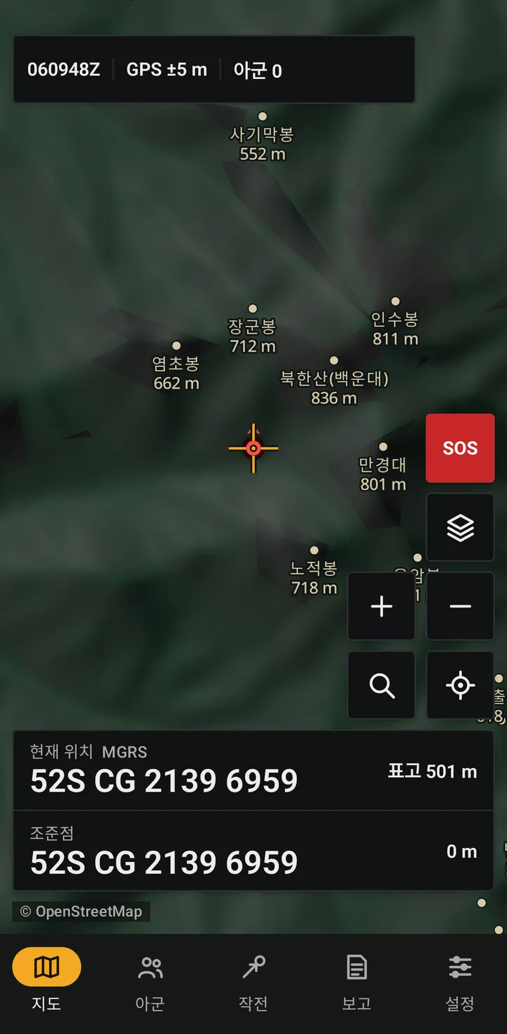
A mobile situational awareness app for Korean terrain. Positions, coordinates, reports and exercise control use one consistent screen layout, and the map keeps working where the network is weak. The app uses the CoT format to interoperate with ATAK users on the same server.
- Devices
- Android 8.0 or later. No iPhone version (iPhone users can join the same server with iTAK)
- Team separation
- Server groups hide the other team's positions; the referee sees everyone
- Offline
- Maps, terrain, coordinates and report writing work without a network
- Server
- Team server based on OpenTAKServer (hosting in Korea recommended)
What goes wrong in the field
- The map goes blank
- In mountains and on islands, online maps stop loading as soon as mobile coverage fades.
- Grid systems get mixed
- The military uses MGRS and mils; rescue calls use the Korean national grid. Each app handles them differently, so people convert by hand.
- Reports come late
- By the time position and time are written down and read over the radio, the situation has moved.
- Tools do not interoperate
- ATAK users and users of other apps find it hard to share a common picture.
Core features
The features you use in the field, grouped by area.
Maps and terrain
- Offline maps of the peninsula
- A built-in national overview map plus regional detail packs. Each pack is verified by SHA-256 before installation.
- Terrain
- Hillshade, elevation and contours from Copernicus GLO-30. Spot heights are read instantly.
- Line of sight and viewshed
- Corrected for earth curvature and refraction. Viewshed out to 2 or 5 km at prone, standing, vehicle or tower height, including ridges beyond the first crest.
- Map sharing
- Transfer map packs to a nearby phone over Wi-Fi or a hotspot without an internet connection.
- Search patterns
- Hasty search grid (500 m area, 25 m spacing), area search grid (1 km area, 100 m spacing) and an expanding-square search around the last known point, laid on the map.
- Route data
- Bearing, distance and pace count for each leg (for use when GPS drops out), plus total climb and descent.
Coordinates and bearings
- MGRS, Korean national grid, UTM-K
- Handles the zone boundaries around the West Sea islands. Supports entry, copying and grid overlays on the map.
- Mils (6400) and degrees
- Magnetic, grid or true north, with WMM2025 declination built in.
- Reticle readout
- Grid, range, bearing and elevation of the map-center reticle, displayed as an instrument readout.
Team positions and comms
- Team positions (PLI)
- Positions pass through a team server (OpenTAKServer) over mutually authenticated TLS. Team-color rings and echelon symbols distinguish units.
- Team chat
- Uses ATAK's GeoChat message format and shows delivered and read receipts.
- Radio silence (EMCON) and low bandwidth
- Radio silence stops transmission; reception and emergency alerts continue. On slow links the app lengthens report intervals.
- Local direct sharing
- When the server is out of reach, share directly with teammates on the same Wi-Fi (ATAK Mesh format; unencrypted, off by default).
Marks, reports and alerts
- Marks and graphics
- MIL-STD-2525 unit symbols, control lines, areas and axes. Routes are sent to the team, and passage along a route is reported.
- Standard reports
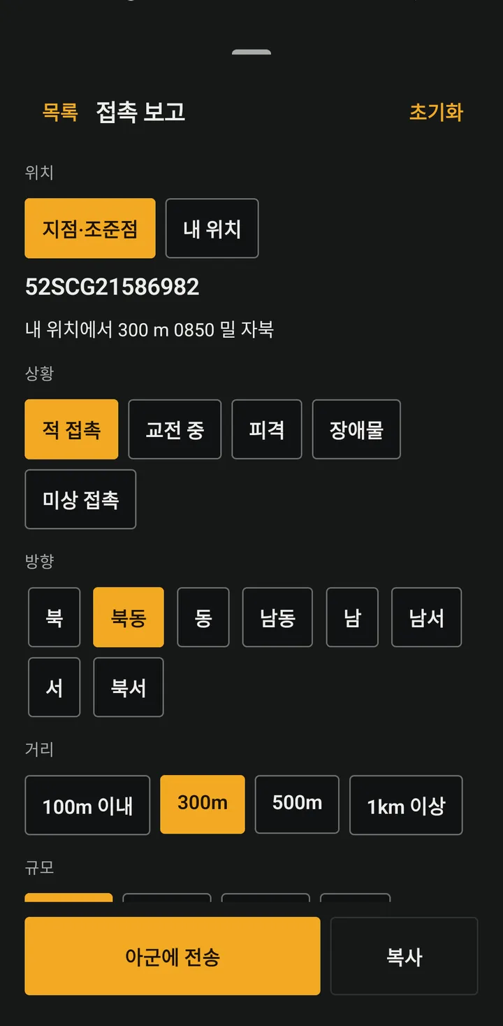
- Contact report, SALUTE, SITREP, 9-line MEDEVAC, LACE and more, with position and DTG filled in.
- Emergency alert
- Press and hold to send. The alert repeats every 30 s and shows which teammates have acknowledged and are responding.
- Field mode
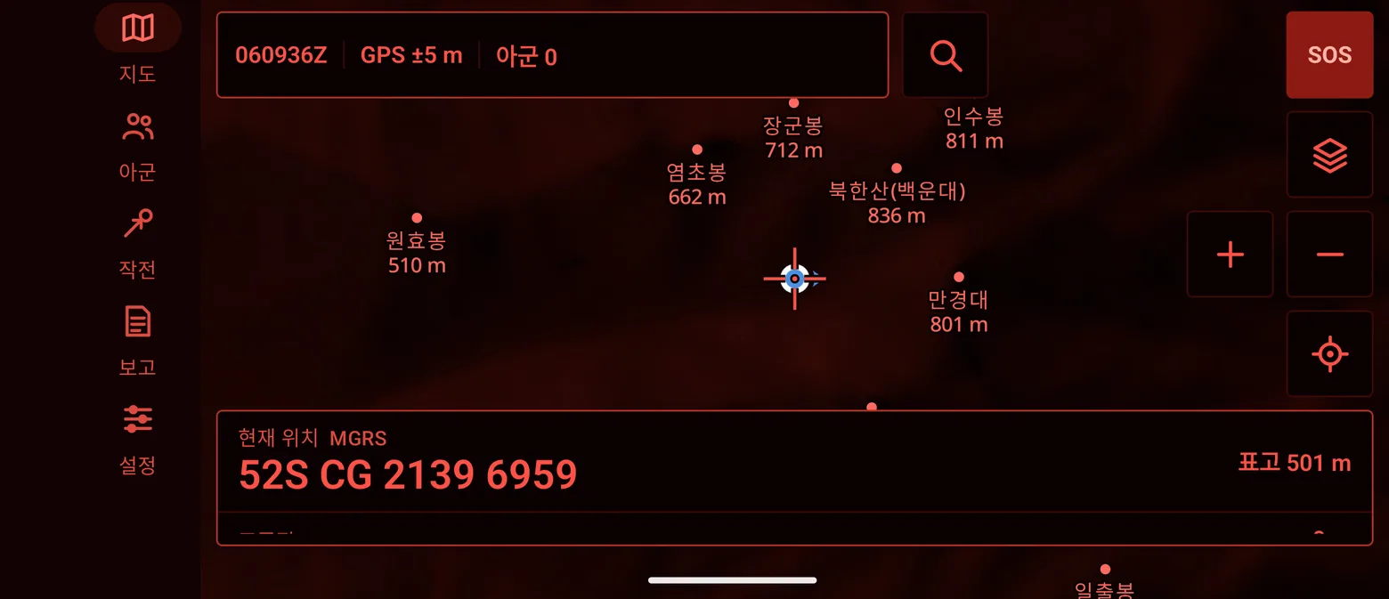
- Large buttons for gloved hands, a red night screen and large text.
Exercise control
- Referee-signed exercises
- Set zones, safe areas, respawn points and objectives. Players confirm the exercise with a check number the referee reads out.
- Hits, respawns, captures
- Round clock, broadcast notices, out-of-bounds alarms, referee handover.
- After-action review
- Track replay alongside the exercise message log, in time order. Records are deleted automatically after the retention period.
Test results
Unit tests run on every build, and the integration tests have passed.
- Unit tests(Included)
- 199 (app 176, coordinate library 23), run on every build
- Coordinates(Included)
- Korean national grid test value (Admiral Yi statue, Gwanghwamun: 다사 5381 5252); WMM2025 declination matches all 100 official test values
- Team server(Included)
- Team separation, spoofing and lost-device tests pass on a local OpenTAKServer 1.7.11
- CoT server integration(Included)
- ATAK-format CoT (PLI, marks, chat, alerts) exchanged through the team server in tests with simulated devices
Interoperability specification
Compiled from the app's source code. Test status is given for each item.
- Server connectionTested (OpenTAKServer 1.7.11)
- Mutual-TLS streaming on 8089, enrollment (client certificate issue) on 8446, map packs on 8444
- Message formatn/a
- CoT XML (TAK Protocol version 0). Version 1 (protobuf) is not supported
- PLITested with simulated devices
- a-f-G-U-C with contact, __group (team color, role), track, status (battery)
- ChatTested with simulated devices
- GeoChat b-t-f (room, direct-message replies); delivered/read receipts use our own type
- EmergencyTested with simulated devices
- b-a-o-tbl, b-a-o-opn, b-a-o-pan, cancel b-a-o-can
- Marks and shapesTested with simulated devices
- MIL-STD-2525D symbols mapped to CoT types, points b-m-p-*, lines and areas u-d-f. Received: circle u-d-c-c, rectangle u-d-r, route b-m-r, freehand
- DeleteTested with simulated devices
- t-x-d-d
- Local sharingTested app-to-app
- UDP multicast 239.2.3.1:6969 (PLI, marks), 224.10.10.1:17012 (chat), unencrypted
- ImportKML/KMZ supported
- KML and KMZ operational graphics. Data packages (.zip) are not supported
- Own extensionn/a
- y-ktak-* types (exercise, receipts, remote wipe); stock ATAK ignores them
| Item | Detail | Test status |
|---|---|---|
| Server connection | Mutual-TLS streaming on 8089, enrollment (client certificate issue) on 8446, map packs on 8444 | Tested (OpenTAKServer 1.7.11) |
| Message format | CoT XML (TAK Protocol version 0). Version 1 (protobuf) is not supported | n/a |
| PLI | a-f-G-U-C with contact, __group (team color, role), track, status (battery) | Tested with simulated devices |
| Chat | GeoChat b-t-f (room, direct-message replies); delivered/read receipts use our own type | Tested with simulated devices |
| Emergency | b-a-o-tbl, b-a-o-opn, b-a-o-pan, cancel b-a-o-can | Tested with simulated devices |
| Marks and shapes | MIL-STD-2525D symbols mapped to CoT types, points b-m-p-*, lines and areas u-d-f. Received: circle u-d-c-c, rectangle u-d-r, route b-m-r, freehand | Tested with simulated devices |
| Delete | t-x-d-d | Tested with simulated devices |
| Local sharing | UDP multicast 239.2.3.1:6969 (PLI, marks), 224.10.10.1:17012 (chat), unencrypted | Tested app-to-app |
| Import | KML and KMZ operational graphics. Data packages (.zip) are not supported | KML/KMZ supported |
| Own extension | y-ktak-* types (exercise, receipts, remote wipe); stock ATAK ignores them | n/a |
Screens
The images above are real app screens. The three drawings below reproduce its screen layout.
3 A1
6 E
9 —
Editions and user groups
Civilian and military pilot editions are available; fire and police editions are configured to each agency's requirements.
- Main users
- Airsoft and milsim teams, outdoor teams
- Distribution
- Direct APK distribution
- App lock
- Optional PIN (duress PIN and dead-man available once set)
- Managed settings
- None
- Report forms
- Standard report forms (same in both)
- Edition-specific features
- Exercise (game) control
- Usable today
- All features
- Main users
- Pilot units
- Distribution
- Unit MDM
- App lock
- Required 6–8 digit PIN, screenshots blocked
- Managed settings
- Allowed server fingerprints, local sharing and export permissions
- Report forms
- Standard report forms (same in both)
- Edition-specific features
- MDM managed settings; no automatic re-enrollment after a wipe
- Usable today
- All features during a pilot
- Main users
- Fire: Incident command and crews / Police: Search and event security
- Report forms
- Fire: Field report forms / Police: Search and security forms
- Edition-specific features
- Fire: Crew status and assembly points / Police: Search grids, expanding square and national-grid search
- Usable today
- Civilian edition: national grid, offline maps, PLI
| Edition | CivilianAvailable | Military pilotBy consultation | FireConfigured to order | PoliceConfigured to order |
|---|---|---|---|---|
| Main users | Airsoft and milsim teams, outdoor teams | Pilot units | Incident command and crews | Search and event security |
| Distribution | Direct APK distribution | Unit MDM | To be agreed | To be agreed |
| App lock | Optional PIN (duress PIN and dead-man available once set) | Required 6–8 digit PIN, screenshots blocked | To be agreed | To be agreed |
| Managed settings | None | Allowed server fingerprints, local sharing and export permissions | To be agreed | To be agreed |
| Report forms | Standard report forms (same in both) | Standard report forms (same in both) | Field report forms | Search and security forms |
| Edition-specific features | Exercise (game) control | MDM managed settings; no automatic re-enrollment after a wipe | Crew status and assembly points | Search grids, expanding square and national-grid search |
| Usable today | All features | All features during a pilot | Civilian edition: national grid, offline maps, PLI | Civilian edition: national grid, offline maps, PLI |
The military pilot edition carries no classified or real operational information and no military geospatial data. Its cryptography is designed to be swapped for a KCMVP-validated module.
How it extends
Included
- Report forms are data files, so a unit can add its own forms without code changes.
- Map packs come from the team server's list and install only when the hash matches.
- The military pilot edition takes server and feature permissions from MDM managed settings.
Custom builds
- Optional feature modules per user group
- Form, overlay and alert-rule bundles for fire and police
- Form and graphics editing in a web console, then distribution
Scenarios
Scenario: a weekend milsim exercise
Forty players in two teams plus a referee, using only current features.
- 0700
Enrollment
Each player scans a printed invitation QR. Callsign and team color are filled in automatically.
- 0730
Maps
Players download the field's regional map pack. The map keeps working in valleys with weak coverage.
- 0800
Exercise setup
The referee places zones, safe areas and objectives on the map and reads out the check number.
- 0900
Movement
A squad leader reads the objective's 8-digit MGRS and magnetic bearing in mils from the reticle and calls it over the radio.
- 1030
Contact report
Marking a point fills in direction and range; the report goes to the team and an enemy mark stays on the map.
- 1200
After-action review
The team reviews track replay alongside the message log. Records are deleted automatically after 24 hours.
Security design
- Mutually authenticated TLS to the server, pinned server CA fingerprint
- On-device records encrypted; the key is destroyed when data is wiped
- PIN, duress PIN, dead-man timer, signed remote wipe from the server (while the device is connected)
- Lost devices cut off within 30 s; server-side position spoofing blocked
- Positions and messages deleted automatically after 24 hours by default
A draft security review pack for unit security review procedures is available.
Request the security review packQuestions
Is it built on ATAK?
No. It is developed independently and contains no ATAK code. It uses the CoT message format, so positions, marks and chat pass between it and ATAK, WinTAK and iTAK on the same TAK server. We have tested server integration with ATAK-format messages. We are not affiliated with or endorsed by the U.S. Government or the TAK Product Center.
Does it work without internet?
Maps, coordinates, terrain and report writing work offline. Sharing team positions needs the team server; when the server is out of reach, phones on the same Wi-Fi can share directly.
What server does it need?
A team server based on OpenTAKServer. We provide setup, invitations, lost-device cut-off and automatic deletion tools. A server hosted in Korea is recommended.
Is there an iPhone version?
Android only for now. iPhone users can join the same server with iTAK to share PLI, chat and marks (by design); exercise control (hits, respawns, captures) works only in the Honey Badger App.
How do I get the civilian edition?
Request it on the Contact page under ‘Civilian edition pilot’ and we will send the installer and enrollment steps. You install the team server yourself with the tools we provide, or we arrange the installation with you.
Does it work alongside Korean military mobile security software?
During a pilot we check how the app behaves on devices with unit security policies and the military mobile security app. We provide a draft security review pack and complete it according to the unit's information security review process.
Does it compute firing data or ballistics?
No. We do not build fire control features. Range rings are a distance reference only.
Where is location history kept?
Only on the devices and the team server, deleted automatically after 24 hours by default. Nothing goes to outside analytics or advertising services.
Plan a pilot with us
Tell us the number of users, the area and your security conditions, and we will propose a pilot setup.